
FLASHBACK #62: Wild In South Africa (Days 12-14)
Day 12 – February 23rd – Port Elizabeth to George
I woke up at 6.50am, the sun shining through the thin curtains in my room. I grabbed a shower, packed my stuff, then went down for breakfast. As I tucked in, I was starting to feel very full from these hearty starts to each day.
The young girl arrived at 8am just as we were leaving. I think she’s got a bit attached to me. She’s a lovely girl, just 20 years old, and still finding her feet in the world. She said she’s going to be in London one day and I promised that I would pop over from Helsinki for a night out!
As we set off, the young girl, her father and the owners of Hallack Manor waved us off. How nice! Or maybe they just wanted to make sure we actually left!
We drove to the north of the city and visited Wia’s in-laws briefly before hooking onto the N2 to drive along what is known as the Garden Route. Heading towards Humansdorp, we passed Jeffrey’s Bay, commonly referred to as J-Bay. Surfing is the main reason why people go to J-Bay; it boasts of having the best waves in the world.
Before entering the heart of the Garden Route, we took a detour along the Blaauwkrantz Pass. We passed meandering routes, deep dropping gorges amid dense vegetation and pretty bridges.
At the end of the pass, we got back onto the N2 and passed some lovely inlets along what Wia explained were some of the most fertile plains. We eventually reached Plettenburg Bay before arriving in Knysna (pronounce nie-snah). Plettenberg Bay is famous for its rare combination of mountains, white sand and crystal blue water.
 Knysna is perched on the edge of a serene lagoon covering 13 square kilometres, surrounded by forests and is said to be the jewel of the Garden Route. The area started as a timber port and ship-building centre, thanks to the lagoon and the rich indigenous forests in the local area.
We stopped by the railway station in town and took a brief walk. Neither hungry nor in the mood to shop, we got back into the car. It was 2pm and, as we continued driving, we listened to the government’s Annual Budget on the radio. Later, we were stuck in a series of road works and, as Wia slept in the back, we listened to the radio; the Treasury Minister said that much progress had been made in South Africa and that progress would continue blah, blah, blah!
The traffic started to move at speed again and we came across some beautiful scenes. We saw a lovely beach near a town called Wilderness and turned off, in search of the ‘Map of Africa’. No, not a map of Africa, but an uncanny natural occurrence resembling a map of Africa itself. After 15 minutes of driving up steeply inclined hills, we were in for a double treat; the ‘Map of Africa’ on one side of the road and, across the road, an awesome view of the coastline.
 Back in the car once again, we rejoined the N2 and came to a series of panoramic observation points; one point took in a railway bridge just before Victoria Bay which looked awesome as it protruded from the mouth of a river.
 Not long after, we arrived in the town of George and located York Street then Belvedere. We would be staying in a Cape-Dutch style gable overnight and, on our arrival, our husband-and-wife hosts were wonderful; Martha was half-English and half-Finnish while Joe was Greek; they had met while Martha was a nurse in South Africa. I never did find out why Joe was in South Africa at the time.
 They had a boxer dog named Parker and, with their lovely house, they had a great setup. Martha showed off Parker’s agility skills and I was impressed by this hyperactive 6 month old boxer's abilities.
It was nearly 5pm and, after a few phone calls, we were off to nearby Mossel Bay to see some boermusik folk; Wia and I took a breather after a while and drove into the town centre. We sat in an outdoor bar and had a drink as night-time arrived on the scene. Mossel Bay, another jewel of the Garden Route, has some historic buildings and, according to my LonelyPlanet guide, boasts of having the only north-facing beach in the country. I suppose that must be good for something, but I haven’t the faintest idea what! We got back to George after 11pm and I went straight to bed!
THE GARDEN ROUTE EXPLAINED by LONELYPLANET
The much-hyped Garden Route encompasses a verdant and highly attractive stretch of coastline from Still Bay in the west to just beyond Plettenberg Bay in the east. Its main attractions are beaches, the forests with some excellent walks and a wide range of activities from diving and sailing to bungee jumping and quadbiking.
The narrow coastal plain is mostly bordered by extensive lagoons that run behind a barrier of sand dunes and superb white beaches. Inland, the Outeniqua and Tsitsikamma Ranges, which are between 1000 and 1700 metres high and crossed by some spectacular road passes, split the coast from the semidesert Karoo.
The Garden Route has some of the most significant tracts of indigenous forest in the country including giant yellowwood trees and many wildflowers. The forests are still havested commercially and there are also large eucalypt and pine plantations. Day 13 – February 24th – George, Cango & Dinner!
I woke up at 7am after a very restless night; I had developed some kind of allergic reaction during the night either to Parker, the boxer, or to dust. My throat was dry, my eyes were itchy and weeping and I had a god-awful snotty nose. Not a pretty sight! Wia offered me an antihistamine which helped to calm things down a bit while the coffee that Kalie made soothed my throat. Otherwise, I was fine.
After a lovely breakfast al-fresco of mieliepap (a cornflour-based porridge) with honey, yoghurt, toast and jam and bacon and eggs, I offered to translate an email into Finnish for Martha who wanted to send it to relatives in Finland.
We left about 9.30am back towards Mossel Bay; Wia had to take photos of the concertinas belonging to old boy, Alan Greene, who lived on the sea. In the meantime, I went to an internet café, checked my email and searched for some accommodation options in Cape Town; I managed to get a self-catering flat in the centre of Waterkant, for R390 / €50. I was pleased.
I sent Kalie a text message that I was finished at the internet café. Wia responded, asking me to meet them back at Alan’s place. I made my way there and, half an hour later, we set off along the R328 towards Oudtshoorn where I would visit the Cango Caves while they would hunt down more boer music folk.

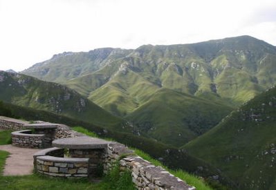
The trip took much longer than we expected. When we got to Oudtshoorn, two things strike you about the place: the presence of numerous ostrich farms and ostrich feathers being sold in virtually every store in the high street and the immaculate Victorian architecture. We drove past Oudtshoorn and continued on our way to Cango via the mountainous and picturesque route.
I napped a while, probably due to a sleep deficit from last night's allergy episode. We arrived at Cango, after passing a number of tobacco plantations, in time for the one-hour 2pm tour. It was grand, majestic and, at times, I was lost for words. Named after the Khoisan word for ‘a wet place’, the Cango Caves are heavily commercialised yet impressive.
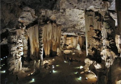 The caves reminded me of a scene at the end of the first Lord of the Rings movie, Fellowship of the Ring. Gandalf, the towering white-haired wizard, was battling against evil in a cave very much like the one I now stood in.
The tour guide, who was black and spoke E`nglish in such a way that each word was separately discernable, was a perfect host for his multi-national audience. As we proceeded along the tour, we gave some history and made some witty jokes. He was good. At the end, in Chamber 6, the guide sang a tribal song and demonstrated the hollowness of some of the cave structures by drumming on translucent, drum-like parts of the formation.
The tour ended at 3.15pm and I met up with Kalie & Wia. We headed off straightaway, first taking the route to Oudtshoorn, then taking in the beautiful Swartberg Pass with it’s meandering routes and beautiful valleys.
 We got back about 4.30pm and we had an hour to get ready for the evening. I put on my bright orange shirt, trousers for the first time on this trip and some smart shoes. We had arranged to meet Glenda, one of Wia’s friends. When we got there, it emerged that she lives in a well-secured cul-de-sac. When she emerged from the house, she was small, frail and gentle looking. In time, I would add cute and funny to the list of words I would add to describe this outrageous character!
It was Glenda’s birthday and, with a glass of wine already in hand, I handed her a present which remained unopened; it was one of those Iittalla candle bases.
One thing is for sure: Glenda isn’t shy! Her husband had passed away a few years back and her son lives in Toronto. Anyway, she told her other guests that Wia and I both worse implants. I reacted with: “Wia might have implants, but there’s nothing wrong with my boobs!” The room erupted in laughter and I think that will always be our joke!
We left the house about 7.30pm, bound for an Italian restaurant in town. I ate a Caesar Salad, Chicken Breast with new potatoes and hot mud cake with ice cream. Wia and I shared a bottle of Nederberg semi-sweet Rosé! Yummy!
We were the last patrons to leave at 10.30pm. When we dropped off Glenda, she hugged me warmly as we said goodbye. She was sooo nice!
We got back to the guesthouse and, as I was packing, I could feel the hayfever or whatever it was coming on again! I took an antihistamine and got into bed about 11.30pm
Day 14 – February 25th – George to Cape Town
We were on the road already by 6am, bound for Cape Town, 444kms away! As soon as we hit the N2, I was asleep once again, waking up at 8.30am when we stopped at a service area for a rest. We ate breakfast on the move, turning off onto Route 319 to take in Cape Agulhas, the Southernmost Point of Africa. We arrived there just before 10am amid a group of crazed Italians who roped me into taking what felt like hundreds of photos. We then had our pictures taken.
From here, you could hear the crashing of the waves against the rugged shore. Imagine: south of here lies the Antarctic. Somewhere, anyway!
We continued back along the way came, but turned off at Bredasdorp onto Route 316. From there, we headed to a small town called Napier; Kalie wanted to track down an author, but did know his address or telephone number. After 30 minutes, admitting defeat, we continued along the route.
Ten kilometres down the road came the familiar sound of a flat tyre. Aw, crap, I thought! We pulled over, detached the trailer, jacked up the car and I got to work. Fifteen minutes later, we were back on the road again.
We stopped in nearby Caledon for an hour to replace the tyre. At 2pm, we set of again along the N2. At this point, we were just 100kms from Cape Town. I napped, but was woken up when we could see the majestic grandeur of the Cape Flats; you see all the suburbs of Cape Town from this vantage point.
We quickly entered the City Limits and came to the end of the N2 at Buitengracht Street. We turned right at the Strand, then into Leather Street where I had to check in for my accommodation.
My accommodation was at 137 Waterkant so I collected my luggage from the boot of the car and they left me there. Checking in at the Village & Life offices had been so quick and easy and when I got into my apartment, I let out a whoop of delight. The place was so great that I took a load of photos.
After settling in, I headed out again at 4pm, ordering a taxi from reception to take me to the base of Table Mountain. I wanted to go to the top, by cable car, since the weather conditions were so good!
I got to the base of Table Mountain, bought my ticket and stood in line, hoping they didn’t cancel the Cable Car for any reason. I was here now and ready to go up Table Mountain! Yay!
By 5pm, I was at the TOP OF TABLE MOUNTAIN. And it was amazing, awesome, fantastic, towering, majestic! You could see Robben Island very clearly which is where Nelson Mandela was imprisoned.
 I took loads of photos before calling Bree and my parents. I was on top of the world, I really was. I was up there for more than an hour despite the chill of the strong winds.
When I took the Cable Car back down, there was no space left in my digital camera! Hardly surprising, really! I left the station and grabbed a taxi; there was no radio centre sending out taxi orders, the price display didn’t work and, after we had been driving for ten minutes, he said he would charge me R60. I had no objection.
I got back about 7pm and headed to the nearest BP garage to muster up some food for dinner. I bought some bread, ham, cheese, crisps and coca-cola. When I got back to the apartment, I made rolls which I downed with a bacardi and coke on the roof garden! Lovely!
I copied the days photos onto the laptop and look at them; the photos from Wilderness and Table Mountain were so beautiful. I updated my diary then set about organising some night life in town by looking at the local tourist guides I had picked up from reception. I checked out a couple of nearby bars and restaurants and got chatting to this guy Andy, from Greenwich in London, UK. This was his sixth visit to SA and he was giving me his side of the story!
Later on, in another bar, a guy named Wesley from East London, South Africa, got talking to me. He was 26 and I joked with him about London. Where’s West London, or North London for that matter in South Africa? Surely, if there’s an East, there should be a North, South and West somehwere? He didn’t have the answer, but we laughed about the senselessness of it all!
Wesley had recently move to Cape Town and, in five months, hadn’t made any friends. He seemed sociable enough, though, so I couldn’t tell what the problem was. Anyway, I had a few drinks, had a bit of a boogie in the crowded bar, but realised it was too busy to dance; somehow, I got an elbow in my face twice!
I got home about 2am and, sitting on the toilet, thought how nice it was to party for a change after all the serious site-seeng! As for falling asleep, I was so tired that I didn’t even have to try!
ABOUT CAPE TOWN
In 1580, Sir Frances Drake described the Cape of Good Hope as ‘the most stately thing, and the fairest Cape we saw in the whole circumference of the world’. The world is a more familiar place these days, but his estimation of what is now Cape Town remains true.
Whicever way you look at it, Cape Town occupies one of the world’s most stunning locations. Few other cities can boast a 1073m-tall mountain slap-bang in their centre. The plateau of Table Mountain and it’s attendant peaks of Devil’s Peak and Lion’s Head are the city’s most enduring image.
More than matching the visual drama of its location has been the cities tumultuous history over the past 350 years. As capital of the West Cape province and parliamentary capital of the republic, Cape Town works as a city in a way that so few on the African continent do. Sadly, though, the scars of the republic’s terrible history still run deep.
In 1998, the complete skeleton of a 3 ½ million year old Australopithecus afrianus was found in a cave near Sterkfontein which should provide new information about human evolution.
In the 15th Century, the Muslim expansion across North Africa and the Balkans had thrown Christian Europe’s trade routes into chaos, prompting the Portuguese and Spanish to search for a sea route to India and the spice islands of South-East Asia. At the end of 1487, Bartholomeu Dias and his expedition rounded a cape, which Dias named Cabo da Boa Esperanca (Cape of Good Hope). Ten years later, Vasco da Gama rounded the Cape and finally reached India in 1498.
In 1652, the Dutch settled in Cape Town. In 1660, in an awfully symbolic gesture, the leader of the initial Dutch East India Company, Jan van Riebeeck, planted a bitter almond hedge to separate the Khoisan tribes and the Europeans. It extended around the the western foot of Table Mountain down to Table Bay – sections of the bush can still be seen in Kirstenbosch Botanical Gardens.
In another move that would have consequences for centuries ahead, Van Riebeeck then proceeded to import slaves from Madagascar, India, Ceylon, Malaya and Indonesia to deal with the colony’s chronic labour shortage.
The population of whites did not reach 1,000 until 1745. There was a shortage of women in the colony, so the Europeans exploited the female slaves for both labour and sex; the offspring of these unions formed the basis of sections of today’s coloured population.
Dutch power was fading by the end of the 18th Century, and in response to the Napoleonic Wars, the British decided to secure the Cape. In 1806, 25km north of Cape Town, the British defeated the Dutch and the colony was ceded to the Crown on 13th August 1814.
The slave trade was abolished in 1808, and all slaves were emancipated by 1833. The British introduced new laws that laid a basis for an exploitative labour system little different from slavery. Thousands of dispossessed blacks sought work in the colony, but it was made a crime to be in the colony without a pass, and without work. It was also a crime to leave your job.
The discovery of gold in the centre of South Africa in the 1870’s and 80’s led to rapid changes. Cape Town was set to benefit from the mineral wealth that would lay the foundations for an industrial society.
In 1869, the Suez Canal opened and Cape Town’s role as ‘Tavern of the Seas’ began to wane. Today, the massive supertankers that are too big to use to Suez are also too big to enter Table Bay, so they are serviced by helicopter.
Cape Town avoided any direct role in the 1899-1902 Anglo-Boer War, but it did play a key role in landing and supplying the 500,000 imperial and colonial troops who fought on the British side.
Bubonic plague in 1901 gave the government an excuse to introduce racial segregation. After the war, however, the British made some efforts towards reconciliation, and moves towards the union of the separate South African provinces were instituted. The issue of which city should become the capital was resolved by a compromise of making Cape Town the seat of legislature, Pretoria the administrative capital and Bloemfontein the judicial capital.
In 1948, the National Party stood for election on its policy of apartheid and narrowly won. In a series of bitter court and constitutional battles, the right of the coloureds to vote in the Cape was removed and the insane apparatus of apartheid was erected.
In 1960, the African National Congree (ANC) and the Pan African Congress (PAC) organised marches against the hated Pass Laws which required blacks and coloured to carry passbooks authorising them to be in a particular area.
In the Cape Flats, police killed five protestors. In response to the crisis, a warrant for the arrest of Nelson Mandela and other ANC leaders was issued. In mid-1963, Mandela was captured and sentenced to life imprisonment on Robben Island in the middle of Table Bay.
The government tried for decades to eradicate squatter towns which were focal points of black resistance to the apartheid regime. In its last attempt between May and June 1986, an estimated 70,000 people were driven from their homes and hundreds were killed.
During the 1990’s, drugs became a problem in the Cape area. In 1995, People Against Gangsterism and Drugs (PAGAD) was formed, but the movement quickly turned sour in 1996 with the horrific (and televised) death of gangster Rashaad Staggie. A lynch mob burned and then repeatedly shot the dying gangster and PAGAD was labelled as a group of violent vigilantes by both white and black politicians. The battles between PAGAD and the gangsters continue; a series of bombings of Cape Town police stations in 1999 and a bomb at the Waterfront have been blamed on them.
Suspicion and mistrust between the black and coloured communities remains one of the more heartbreaking legacies of apartheid. In an effort to work towards what former Archbishop Demond Tutu called the Rainbow Nation, the local media launched a ‘One City, Many Cultures’ program in 1999. It has proven popular.
The process of integration, mutual acceptance and understanding is being further helped along by the restructuring of Cape Town’s local government to create six councils, each covering a broad range of communities, rich and poor, black, white and coloured.
posted by About Me: @ 10:24 pm
![]()
![]()
<< Home